Planet Earth/4j. Storm Tracking
Hurricanes and Typhoons
edit
On August 23, 2005, meteorologists noticed a tropical depression of low pressure in the Atlantic Ocean intensifying into a tropical storm as it headed toward the east coast of Florida. The storm quickly strengthened into a hurricane a few hours before making landfall north of Miami, Florida. It crossed over the tip of Florida, and emerged over the Gulf of Mexico on August 26 and continued to strengthen into a truly massive storm—a Category 5 hurricane. The gigantic storm formed an eye, a zone of low pressure in its center, as strong winds blew inward to its center. From space, the vortex of the storm was the only clear point in an expansive coverage of dark clouds. These heavy clouds and intense rain were formed by the quickly rising moist warm air from the waters of the Gulf of Mexico generating low pressure beneath this rising air. The storm slammed into southeastern Louisiana and Mississippi. The hurricane was named Katrina, by the World Meteorological Organization, which names Atlantic hurricanes from a rotating list. Katrina caused considerable destruction and casualties when it made landfall. An estimated 1,245–1,836 Americans died in the hurricane and subsequent floods, making Katrina one of the deadliest of hurricanes in the United States.
How can scientists track the motion and predict the landfall of storms, such as Katrina? Hurricanes are a special type of cyclone storm that is regionally confided to the Atlantic and Gulf of Mexico, as well as the northwestern Pacific Ocean waters. The word Hurricane comes from the Mayan God, Hunraqan, and first used in antiquity by Kʼicheʼ people of Guatemala. The term is used exclusively in the Americas. While in Asia and India the term Typhoon is used. The word Typhoon comes from Mandarin, Arabic, Persian and Hindi pronunciations for the term for large wind storms. The Ancient Greek term Τυφῶν (Tuphôn) is related to the Serpent-like god Typhon who challenged Zeus for supremacy of the universe, and breathed smoke, mist and wind storms.

The technical or scientific term cyclone refers to any extensive storm characterized by wind blowing spirally around a calm center of a vortex. Both hurricanes and typhoons are simply colloquial terms for large cyclones. Cyclones produce wind speeds greater than 74 miles per hour (119 km/h), and form exclusively over oceans. When they make landfall, they cause considerable damage, but often break up over the higher topography on continents, so are a particular hazardous to coastlines. Tropical cyclones are grouped into 5 categories depending on their wind speed. Category 1 cyclones have wind speeds between 74-95 mph, Category 2 have wind speeds between 96-110 mph, Category 3 have wind speeds between 111-129 mph, with Category 4 wind speeds between 130-156 and Category 5 winds speeds greater than 157 mph. All these high wind speeds can cause considerable damage to structures. The categories also correspond to increasing storm surges, in rising ocean waters and potential for major coastline flooding.

The formation of cyclones in the Atlantic, Pacific and Indian Oceans are a result of the complex interaction between the ITCZ (the InterTropical Convergence Zone) a low-pressure zone near the equator and the high-pressure subtropical zone. Easterly winds blow from the high-pressure zone into the ITCZ. During the late summer months of August, September, and October, the ITCZ in the Northern Hemisphere moves northward due to the increasing thermal gradient from the later summer heat from the sun. These low-pressure zones result from the rising warm air above the oceans, causing air from the more northern high-pressure subtropical zones to blow into these depressions of low pressure. Pockets of low pressure form due to the Earth’s spin toward the east, causing waves of high pressure to crest, and near the back side of the cresting high pressure systems a depression of low-pressure forms (these waves are Rossby Waves, caused by the spin of the Earth and pressure gradients). These pockets of low-pressure result from rising air masses above seasonally warm ocean waters, and because they trail a high-pressure system, a huge amount of air can rush in to fill these low-pressure areas, resulting in high wind speeds. All cyclones on Earth move from the east toward the west, they never cross the equator and are only located at the maximum seasonal latitude of the ICTZ, often south of the high-pressure subtropical zone, and rarely extend north of 40 degrees latitude or south of 40 degrees latitude.
Storms that form north of the equator spin counterclockwise, while storms south of the equator spin clockwise. As air rushes into the center of the storm it is deflected slightly to the right in the northern hemisphere overshooting the low-pressure center of the storm and will spiral back to the left causing the center to spin counterclockwise. In the southern hemisphere the opposite happens. However, the overall path of the storms will follow a curved clockwise direction in the North Hemisphere, and curved counterclockwise direction in the South Hemisphere due to the Coriolis Effect. This will make cyclones appear to spiral in the opposite motion of their overall movement.
Cyclone Paths across Earth’s Surface
edit
A history of Earth’s cyclone paths demonstrates a very narrow time of year and overall direction that they travel by. The Northern Atlantic Ocean and Gulf of Mexico are major regions for hurricane activity in August, September and October. During these months the ITCZ has moved low pressure warm air northward, causing storms to move from the eastern offshore regions of the Atlantic Ocean, across the Caribbean Islands and Florida, into the Gulf of Mexico or to head northward along the Southeastern Coast of North America. Large cyclones like those formed in the Gulf of Mexico rarely form in the Mediterranean Sea. This is because the Mediterranean Sea lays between 30 to 46 degrees north latitude within the high-pressure subtropical zone, and the low-pressure zone necessary for large storms to form never extends this far north. The Gulf of Mexico and surrounding Atlantic Ocean is farther south, with latitudes extending from 21 degrees north to 30 degrees and much closer to the formation of large cyclones associated with low-pressure ITCZ, especially in the late summer months.
Southeastern Asian countries are also within the easterly motion of cyclones on the western side of the Pacific Ocean. Here typhoons blow out of the east against the coastlines of southeastern China, and northward toward Korea and Japan. Some cyclones can form in the Indian Ocean and strike against the eastern coastline of India and Bangladesh causing major flooding with rising storm surges.
In the South Atlantic cyclones are rare, despite the Brazilian coast being situated at ideal latitudes for their formation. The only recent hurricane to make landfall in Brazil was Catarina in 2005. The reason for the rarity of hurricanes in the South Atlantic is because of the colder ocean waters of the open Atlantic Ocean as well as stronger wind shear off the coast of Brazil. Most of these cyclones appear in the Southern Hemisphere summer months of January, February and March. Southern Hemisphere cyclones are much more common and dangerous in the Indian Ocean, and can strike the East African coastline. In 2019 cyclone Idai hit Mozambique flooded the city of Beira on the East Africa coast. In the Pacific Ocean, the Southern Hemisphere can host cyclones that impact northern Australia and New Guinea. In March 2019, cyclone Trevor struck the Northern Territory of Australia.
Cyclones in a Warming Earth
edit.jpg)
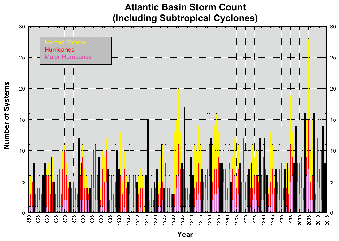
One of the major scientific questions about cyclones is whether they will increase in frequency as the Earth’s atmosphere warms with increasing carbon dioxide. To answer this question, scientists construct computer models of the Earth’s atmosphere and play out differences in the absorption of heat in the modeled atmosphere. From these models, there is surprisingly little confidence on whether the frequency of cyclones increases with a warming planet. However, there is strong consensus that the ITCZ will increase poleward, resulting in an increasingly broader range of future storm tracks, with increasing likelihood that latitudes north and south of 30 degrees could be hit by future storms. The other strong consensus is that because of the increased atmospheric heat, precipitation (the amount of rainfall) produced by cyclones will increase. The amount of rainfall increasing with warming temperatures in the atmosphere will heavily impact coastal areas with increasing floods, and will likely make coastal regions more prone to future flooding. Further increases in sea level will also contribute to rising amounts of coastline flooding during storm surges. Here is a link to a chart of all Atlantic Storms from 1855, until 2015, showing a slight upward trend.
| Previous | Current | Next |
|---|---|---|