A Chronological Survey of Sedimentary Landforms in the Continental United States/Cambrian
| Cambrian period 542± 0.3 Ma to 488.3± 1.7 Ma | |
| Mean atmospheric O2 content over period duration | ca. 12.5 Vol %[1] (63 % of modern level) |
| Mean atmospheric CO2 content over period duration | ca. 4500 ppm[2] (16 times pre-industrial level) |
| Mean surface temperature over period duration | ca. 21 °C [3] (7 °C above modern level) |
| Sea level (above present day) | Rising steadily from 30m to 90m |
The Cambrian is the first period of the Paleozoic era of the Phanerozoic eon. The beginning of Cambrian time coincides with a mass extinction event that depleted late Precambrian life forms and made way for a virtual explosion of new life. It is thought that the Ediacaran period, which closed Precambrian time, saw the emergence of Earth from a long and bitter ice age. Melting ice and warming temperatures encouraged the growth of algae and other oxygen producing organisms. The atmospheric oxygen content, which had been as low as 8% during the Ediacaran, increased to 12.5%. At the same time, volcanic gases were pumping carbon dioxide into the atmosphere, creating a greenhouse effect that reinforced the warming trend.
The Cambrian climate on the global scale was much warmer than we see today. Other than some primitive algal and lichen species, there were no land plants and certainly no land animals. But life in the warm, shallow seas was abundant and diversified. The Cambrian was characterized by transgressive-regressive episodes during which the sea levels repeatedly shifted. It is thought that this resulted from a combination of rapid continental drift and the melting of the last remnants of the previous ice caps.
One cannot talk about Cambrian life forms without mentioning the famed Burgess Shale (Wikipedia article), but strictly speaking, the bulk of that locality lies in Canada. We will therefore confine our locality discussion to the Sauk Transgression, as typified in the lowermost sedimentary formations of the Grand Canyon in Arizona.
During Cambrian time, shallow epeiric seas covered large portions of the continent. The general trend was toward increasing depth and areal extent of these seas, but there were also numerous episodes of retreating seas as land masses were uplifted by tectonic forces. The Sauk Sequence is, therefore, typically interfingered with units grading laterally into each other, and sequence repetitions are abundantly present. For any given shoreline position, the sequence nearest shore consists of light colored sands, silts, and muds, sometimes containing thin limestone bands. Farther out, pure limestones and dolomites accumulated. Then, in the deeper waters farther offshore, dark colored silts, muds and sands, and impure limestone beds that contain chert are found. It is important to realize that these interlaced facies do not represent different times of deposition, but merely different environments. Thus, in the basal layers of the Grand Canyon, we see the Lower Cambrian Tapeats Sandstone being deposited near shore, grading to the eastward into the Bright Angel Shale, which in turn grades into the Muav Limestone. The Bright Angel Shale is a classic example of a formation that represents different intervals of deposition at different places. Because the trend of Sauk transgression in this region was from west to east, the Bright Angel Shale follows this path laterally with respect to time. Thus, in the westernmost exposures, the Bright Angel Shale is partly of Lower Cambrian age, while the easternmost exposures are entirely Middle Cambrian.

The transition from sandstone to shale to carbonates is the classic signature of a transgressive event. Regressive events may show the reverse sequence, if the regression was also a slow event. (Some regressions were the result of rapid crustal movements, and did not allow time for the sedimentation to occur). If an uplifted region became exposed to erosion at any time, there may also be missing sequences and a visible unconformity in the bedding.
Late Cambrian sedimentation patterns shifted more toward carbonate sequences, indicative of stabilizing sea levels and somewhat deeper waters. Stromatolitic algal limestone reefs became common, which means that shorelines had stabilized as well. There is no stratigraphic boundary between the Cambrian and the overlying Ordovician periods. The two are distinguished entirely by means of the fossil assemblages. The Cambrian climate trends therefore continued unchanged into the Ordovician period.
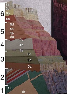
In the diagram at right, unit 3a is the Tapeats Sandstone, lying unconformably upon the Precambrian granite and schist. Unit 3b, which is softer and thus forms an erosional slope, is the Bright Angel Shale. Finally, unit 3c is the Muav Limestone. Together, this sequence is called the Tonto Group.

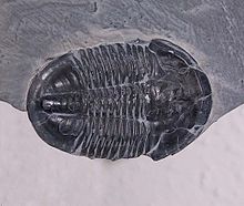
Trilobite fossils are the most famous specimens from the Cambrian period. However, the Archaeocyathids (Wikipedia article) and Brachiopods (Wikipedia article) are, by far, the more useful groups, being marker species for the period. The Archaeocyathids first appear at the Ediacaran-Cambrian boundary, and became extinct by the Middle Cambrian. The Brachiopods appeared in both articulated and inarticulated forms, but only the inarticulated forms were abundant in the Cambrian. The articulated species dominate after the Cambrian-Ordovician boundary. Thus, these two fossil species can be used to date a Cambrian formation. Although all the major invertebrate phyla appear during the Cambrian, nearly all Cambrian macrofossils belong to the three groups mentioned. Other large life forms appear to have been rare, or not to have fossilized well.
The Cambrian period introduced such a rapid expansion of life forms that it has been called the Cambrian Explosion (Wikipedia article). The seemingly sudden proliferation of diverse species is something of a mystery, but interpretation is difficult due to a limited supply of evidence, incomplete fossil records, and the lack of chemical traces left in Cambrian rocks.