File:Finnish areas ceded in 1940.png

Size of this preview: 464 × 600 pixels. Other resolutions: 186 × 240 pixels | 619 × 800 pixels.
Original file (619 × 800 pixels, file size: 26 KB, MIME type: image/png)
|
|
This is a file from the Wikimedia Commons |

|
This military map image could be re-created using vector graphics as an SVG file. This has several advantages; see Commons:Media for cleanup for more information. If an SVG form of this image is available, please upload it and afterwards replace this template with
{{vector version available|new image name}}.
It is recommended to name the SVG file “Finnish areas ceded in 1940.svg”—then the template Vector version available (or Vva) does not need the new image name parameter. |
Summary
| Description |
[]
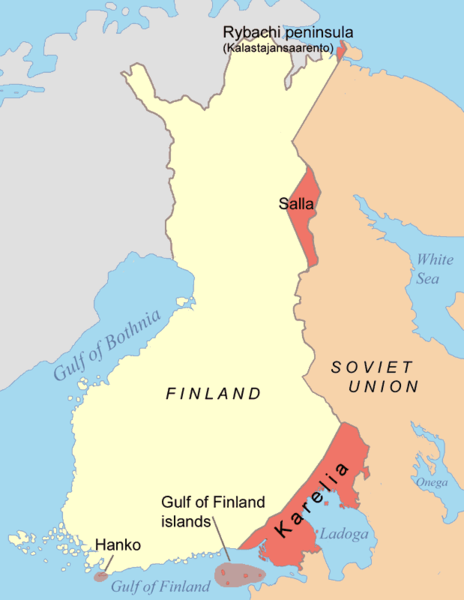
Čeština: Mapa finsko-ruské hranice po Moskevském míru. Deutsch: Karte der Gebiete, die nach dem Winterkrieg 1940 von Finnland an die Sowjetunion abgetreten wurden. Eesti: Moskva rahulepinguga Talvesõja järel Nõukogude Liidule läinud alad. English: Map of the areas ceded by Finland to the Soviet Union after the Winter War 1940. Français : Territoires cédés par la Finlande à la Russie en 1940, après la Guerre d'Hiver. Italiano: Mappa delle rettifiche territoriali subite dalla Finlandia a favore dell'Unione Sovietica dopo la Guerra d'inverno (1940). Magyar: A kép a Téli háborút lezáró Moszkvai béke alapján Finnországtól a Szovjetuniónak átadott területeket mutatja Suomi: Suomen Moskovan rauhassa vuonna 1940 menettämät alueet. Русский: Карта территорий, переданных Финляндией Советскому Союзу после Зимней войны 1940 года. 中文: 冬季戰爭後芬蘭割給蘇聯的領土 العربية : الأراضي التي تنازلت فنلندا عنها بموجب معاهدة موسكو للسلام التي أنهت حرب الشتاء |
||||||||
| Date | |||||||||
| Source | Own work | ||||||||
| Author | Jniemenmaa | ||||||||
| Permission (Reusing this file) |
I, the copyright holder of this work, hereby publish it under the following licenses:
You may select the license of your choice. |
||||||||
| Other versions |
[]
|


.png)


File history
Click on a date/time to view the file as it appeared at that time.
| Date/Time | Thumbnail | Dimensions | User | Comment | |
|---|---|---|---|---|---|
| current | 19:44, 14 June 2015 | | 619 × 800 (26 KB) | RokerHRO | optipng -o7 -i0 → 61.16% decrease |
| 09:48, 7 June 2015 |  | 619 × 800 (68 KB) | Hohum | Clearer colours | |
| 13:45, 2 February 2015 |  | 619 × 800 (31 KB) | RokerHRO | optipng -o7 -i0 → 41.00% decrease | |
| 07:18, 10 September 2005 |  | 619 × 800 (52 KB) | Jniemenmaa | Map of Finnish areas ceded to the Soviet Union in 1940, after the Winter War. Category:Finland |
File usage
The following page uses this file:
Global file usage
The following other wikis use this file:
- Usage on an.wikipedia.org
- Usage on ast.wikipedia.org
- Usage on az.wikipedia.org
- Usage on be-tarask.wikipedia.org
- Usage on be.wikipedia.org
- Usage on bg.wikipedia.org
- Usage on ca.wikipedia.org
- Usage on da.wikipedia.org
- Usage on de.wikipedia.org
- Usage on el.wikipedia.org
- Usage on en.wikipedia.org
- Usage on en.wiktionary.org
- Usage on eo.wikipedia.org
- Usage on eu.wikipedia.org
- Usage on fa.wikipedia.org
- Usage on fr.wikipedia.org
- Usage on fy.wikipedia.org
- Usage on gl.wikipedia.org
- Usage on hr.wikipedia.org
- Usage on hu.wikipedia.org
- Usage on id.wikipedia.org
- Usage on it.wikipedia.org
- Usage on ja.wikipedia.org
- Usage on ko.wikipedia.org
- Usage on lv.wikipedia.org
- Usage on nl.wikipedia.org
- Usage on nn.wikipedia.org
- Usage on no.wikipedia.org
- Usage on pl.wikipedia.org
- Usage on pt.wikipedia.org
View more global usage of this file.