File:Vorderhopfreben Üntschenspitze 1.jpg

Size of this preview: 800 × 322 pixels. Other resolutions: 320 × 129 pixels | 640 × 257 pixels | 1,024 × 412 pixels | 1,280 × 514 pixels | 2,560 × 1,029 pixels | 6,439 × 2,588 pixels.
Original file (6,439 × 2,588 pixels, file size: 4.83 MB, MIME type: image/jpeg)
|
|
This is a file from the Wikimedia Commons |
|

| Description |
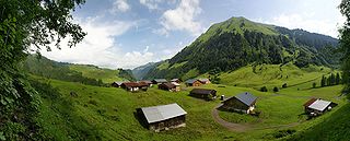
Deutsch: 180° Panorama auf dem Vorsäß Vorderhopfreben mit Blick auf das höher gelegene Vorsäß „Schalzbach“ in Schoppernau. Beide Siedlungen gehören zur Stufe zwei der Dreistufenwirtschaft. Rechts im Bild die Üntschenspitze 2.135m.
English: 180 ° panorama on the Alps Vorderhopfreben with a view of the higher-lying Alps Schalzbach in Schoppernau. Both settlements are in stage two of the three-stage Transhumance in the Alps. Right in the picture Üntschenspitze 2,135m.
Français : Panorama à 180 ° sur des alpages de Schoppernau, dans le Vorarlberg, en Autriche. Les deux alpages de Vorderhopfreben et Schalzbach visibles ici sont des stations intermédiaires entre la vallée et les alpages d'altitude. Sur la droite de l'image on peut voir le sommet de l'Üntschenspitze (2 135 m).
|
||
| Date | |||
| Source | Own work | ||
| Author | Böhringer Friedrich | ||
| Permission (Reusing this file) |
I, the copyright holder of this work, hereby publish it under the following license: This file is licensed under the Creative Commons Attribution-Share Alike 2.5 Generic license.
|
||
| Other versions |
|


| Camera location | | View this and other nearby images on: OpenStreetMap |
|---|
This Photo was taken by Böhringer Friedrich.
|
Feel free to use my photos, but please mention me as the author and if you want send me a message. or (rufre@lenz-nenning.at) |
| Annotations | This image is annotated: View the annotations at Commons |
File history
Click on a date/time to view the file as it appeared at that time.
| Date/Time | Thumbnail | Dimensions | User | Comment | |
|---|---|---|---|---|---|
| current | 20:44, 12 July 2009 | 6,439 × 2,588 (4.83 MB) | Böhringer | stitching errors corrected 2. Versuch | |
| 20:35, 12 July 2009 | 6,439 × 2,588 (4.83 MB) | Böhringer | stitching errors corrected | ||
| 19:16, 6 July 2009 | 6,439 × 2,588 (5.46 MB) | Böhringer | {{Information |Description= {{de|180° Panorama auf dem Vorsäß Vorderhopfreben mit Blick auf das höher gelegene Vorsäß „Schalzbach“ in Schoppernau. Beide Siedlungen gehören zur Stufe zwei der [[:de:Dreistu |
File usage
The following page uses this file:
Global file usage
The following other wikis use this file:
- Usage on ar.wikipedia.org
- Usage on azb.wikipedia.org
- Usage on az.wikipedia.org
- Usage on bs.wikipedia.org
- Usage on de.wikipedia.org
- Usage on en.wikipedia.org
- Usage on eo.wikipedia.org
- Usage on fr.wikipedia.org
- Usage on gl.wikipedia.org
- Usage on hy.wikipedia.org
- Usage on kn.wikipedia.org
- Usage on krc.wikipedia.org
- Usage on mad.wikipedia.org
- Usage on mg.wikipedia.org
- Usage on min.wikipedia.org
- Usage on nl.wikipedia.org
- Usage on pl.wikipedia.org
- Usage on pnb.wikipedia.org
- Usage on sd.wikipedia.org
- Usage on sl.wikipedia.org
- Usage on tr.wikipedia.org
- Vorarlberg
- Vikipedi:Seçkin resimler/Mekânlar/Panorama
- Vikipedi:Seçkin resim adayları/Vorderhopfreben Üntschenspitze 1.jpg
- Schoppernau
- Vikipedi:Seçkin resim adayları/Arşiv/Şubat 2010
- Vikipedi:Günün seçkin resmi/Ağustos 2011
- Şablon:GSR/2011-08-14
- Vikipedi:Seçkin resimler/Ana sayfaya çıkmış resimler/2011 listesi
- Vikipedi:Seçkin resimler/Ana sayfaya çıkmış resimler/2014 listesi
- Vikipedi:Günün seçkin resmi/Aralık 2014
- Şablon:GSR/2014-12-08
- Şablon:GSR/2017-09-29
- Vikipedi:Günün seçkin resmi/Eylül 2017
- Usage on uk.wikipedia.org
- Usage on vi.wikipedia.org