File:Proportion of land in agriculture by state 2012.png

Size of this preview: 800 × 518 pixels. Other resolutions: 320 × 207 pixels | 640 × 414 pixels | 1,024 × 663 pixels | 1,280 × 828 pixels | 2,560 × 1,656 pixels | 5,100 × 3,300 pixels.
Original file (5,100 × 3,300 pixels, file size: 765 KB, MIME type: image/png)
|
|
This is a file from the Wikimedia Commons |
Summary
| Description |
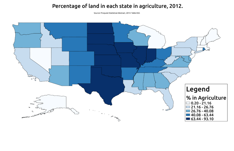
English: This is a map of the US showing the proportion of land in each state that is used for agriculture as of 2012. The data come from Proquest's Statistical Abstract of the US, 2014. |
| Date | |
| Source | Own work |
| Author | Rcragun |
Licensing
I, the copyright holder of this work, hereby publish it under the following license:
This file is licensed under the Creative Commons Attribution-Share Alike 3.0 Unported license.
- You are free:
- to share – to copy, distribute and transmit the work
- to remix – to adapt the work
- Under the following conditions:
- attribution – You must give appropriate credit, provide a link to the license, and indicate if changes were made. You may do so in any reasonable manner, but not in any way that suggests the licensor endorses you or your use.
- share alike – If you remix, transform, or build upon the material, you must distribute your contributions under the same or compatible license as the original.
File history
Click on a date/time to view the file as it appeared at that time.
| Date/Time | Thumbnail | Dimensions | User | Comment | |
|---|---|---|---|---|---|
| current | 17:51, 26 June 2014 | | 5,100 × 3,300 (765 KB) | Rcragun | User created page with UploadWizard |
File usage
The following 2 pages use this file: