File:Missouri Compromise Line.svg

Size of this PNG preview of this SVG file: 800 × 495 pixels. Other resolutions: 320 × 198 pixels | 640 × 396 pixels | 1,024 × 633 pixels | 1,280 × 791 pixels | 2,560 × 1,583 pixels | 959 × 593 pixels.
Original file (SVG file, nominally 959 × 593 pixels, file size: 80 KB)
|
|
This is a file from the Wikimedia Commons |
| Description |
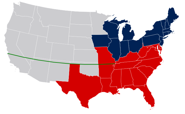
United States map with Missouri Compromise Line. Legend: Free states as of 1850 Slave states as of 1850 (not including Texas claims surrendered in Compromise of 1850) Border slave states that did not later secede in 1861 Territories (with eventual state boundaries superimposed, and including later Gadsden Purchase of 1853) Missouri Compromise Line |
| Date | (UTC) |
| Source | |
| Author |
| This is a retouched picture, which means that it has been digitally altered from its original version. The original can be viewed here: US Secession map 1865.svg:
|
I, the copyright holder of this work, hereby publish it under the following licenses:

|
Permission is granted to copy, distribute and/or modify this document under the terms of the GNU Free Documentation License, Version 1.2 or any later version published by the Free Software Foundation; with no Invariant Sections, no Front-Cover Texts, and no Back-Cover Texts. A copy of the license is included in the section entitled GNU Free Documentation License. |
This file is licensed under the Creative Commons Attribution-Share Alike 3.0 Unported license.
- You are free:
- to share – to copy, distribute and transmit the work
- to remix – to adapt the work
- Under the following conditions:
- attribution – You must give appropriate credit, provide a link to the license, and indicate if changes were made. You may do so in any reasonable manner, but not in any way that suggests the licensor endorses you or your use.
- share alike – If you remix, transform, or build upon the material, you must distribute your contributions under the same or compatible license as the original.
You may select the license of your choice.
Original upload log
This image is a derivitive work of the following images:
- File:US_Secession_map_1865.svg licensed with Cc-by-sa-3.0, PD-USGov-Atlas
- 2008-03-06T09:50:20Z Escondites 927x588 (238383 Bytes) {{Information |Description= |Source= |Date= |Author= |Permission= |other_versions= }}
- 2007-06-26T19:14:18Z Nostrifikator 882x553 (104504 Bytes) {{Tintazul |Description=United States map of 1865, show affiliation of states and territories regarding the Secession War (Civil War.) Legend: {{legend|#003366|Union states}} {{legend|#0197fd|Union territories}} {{legend|#EDD
- 2007-02-23T17:10:23Z Tintazul 882x553 (104420 Bytes) {{Tintazul |Description=United States map of 1865, show affiliation of states and territories regarding the Secession War (Civil War.) Legend: {{legend|#204A87|Union states}} {{legend|#729FCF|Union territories}} {{legend|#EDD
Uploaded with derivativeFX
File history
Click on a date/time to view the file as it appeared at that time.
| Date/Time | Thumbnail | Dimensions | User | Comment | |
|---|---|---|---|---|---|
| current | 00:12, 17 April 2011 | | 959 × 593 (80 KB) | JWB | Blank the line east of the Mississippi |
| 22:38, 16 April 2011 |  | 959 × 593 (80 KB) | JWB | Remove coloring for states that did not yet exist in 1850. Reduce color difference between slave states that did or did not later stay in the Union. | |
| 19:03, 16 February 2011 |  | 959 × 593 (80 KB) | Holly Cheng | oops, messed up Kansas | |
| 18:59, 16 February 2011 |  | 959 × 593 (80 KB) | Holly Cheng | Image won't thumbnail anymore. Recreated using File:Blank US map.svg. | |
| 16:40, 1 October 2009 |  | 927 × 588 (233 KB) | JWB | {{Information |Description=United States secession map of 1865, plus Missouri Compromise Line. Legend: {{legend|#204A87|Union states}} {{legend|#729FCF|Union territories not permitting slavery}} {{legend|#EDD400|Border Union states, permitting slavery}} { |
File usage
The following 2 pages use this file:
Global file usage
The following other wikis use this file:
- Usage on ar.wikipedia.org
- Usage on ca.wikipedia.org
- Usage on en.wikipedia.org
- Usage on en.wikiversity.org
- Usage on eo.wikipedia.org
- Usage on fr.wikipedia.org
- Usage on ha.wikipedia.org
- Usage on hu.wikipedia.org
- Usage on it.wikipedia.org
- Usage on ja.wikipedia.org
- Usage on ko.wikipedia.org
- Usage on ms.wikipedia.org
- Usage on no.wikipedia.org
- Usage on oc.wikipedia.org
- Usage on pt.wikipedia.org
- Usage on simple.wikipedia.org
- Usage on sv.wikipedia.org
- Usage on th.wikipedia.org
- Usage on zh.wikipedia.org