File:Kaieteur Falls Guyana (2) 2007.jpg
Size of this preview: 800 × 420 pixels. Other resolutions: 320 × 168 pixels | 640 × 336 pixels | 1,024 × 538 pixels | 1,280 × 673 pixels | 3,844 × 2,020 pixels.
Original file (3,844 × 2,020 pixels, file size: 1.22 MB, MIME type: image/jpeg)
|
|
This is a file from the Wikimedia Commons |
_2007.jpg)
Summary
| Description |
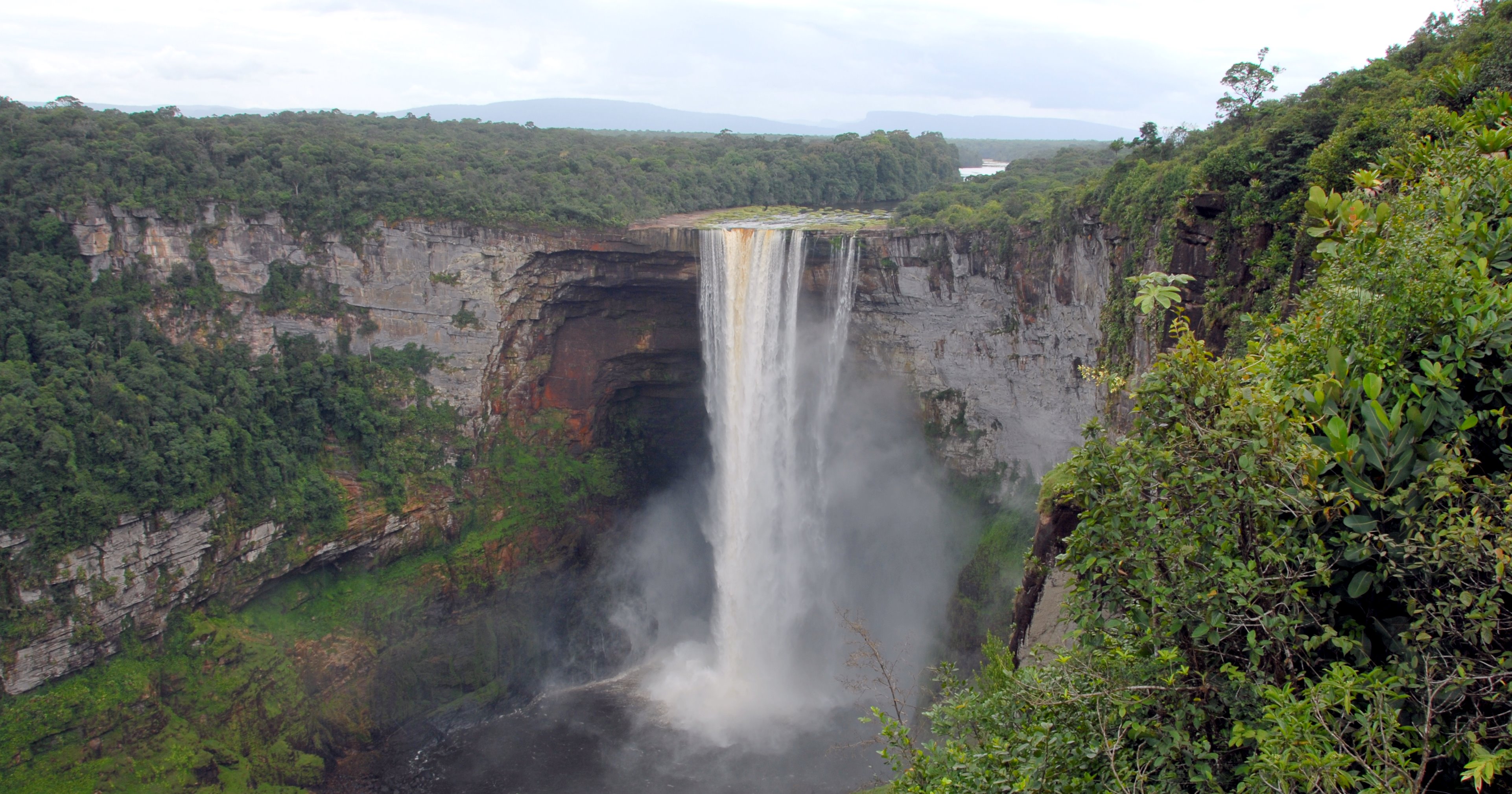
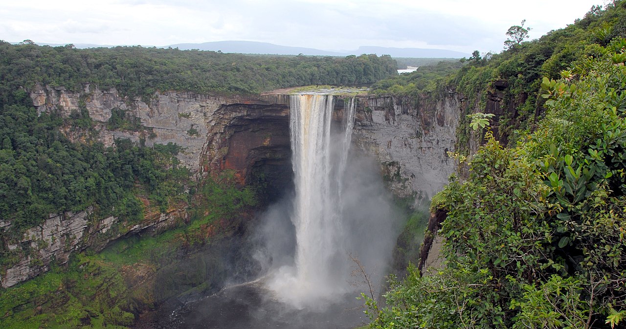
English: Kaieteur Falls is a high-volume waterfall on the Potaro River in central Guyana. |
| Date | Taken on 24 February 2007 |
| Source | Self-photographed |
| Author | Bill Cameron |
| Permission (Reusing this file) |
free access with attribution (my own photograph) |
| Other versions |
Derivative works of this file: Guyana banner.jpg: |
| Camera location | | View this and other nearby images on: OpenStreetMap |
|---|
_2007.jpg¶ms=005.178483_N_-059.482042_E_globe:Earth_type:camera_heading:157.50&language=en)
Licensing
I, the copyright holder of this work, hereby publish it under the following licenses:

|
Permission is granted to copy, distribute and/or modify this document under the terms of the GNU Free Documentation License, Version 1.2 or any later version published by the Free Software Foundation; with no Invariant Sections, no Front-Cover Texts, and no Back-Cover Texts. A copy of the license is included in the section entitled GNU Free Documentation License. |
| This file is licensed under the Creative Commons Attribution-Share Alike 3.0 Unported license. | ||
| ||
| This licensing tag was added to this file as part of the GFDL licensing update. |
You may select the license of your choice.

|
This image has been assessed under the valued image criteria and is considered the most valued image on Commons within the scope: Kaieteur Falls, Guyana. You can see its nomination here. |
_2007.jpg)
File history
Click on a date/time to view the file as it appeared at that time.
| Date/Time | Thumbnail | Dimensions | User | Comment | |
|---|---|---|---|---|---|
| current | 18:58, 23 February 2007 | | 3,844 × 2,020 (1.22 MB) | Bcameron54 | {{Information |Description= Kaieteur Falls, Guyana |Date= February 24th, 2007 |Author= Bill Cameron |Permission= free access with attribution (my own photograph) }} |
File usage
The following 2 pages use this file:
Global file usage
The following other wikis use this file:
- Usage on ar.wikipedia.org
- Usage on ast.wikipedia.org
- Usage on bg.wikipedia.org
- Usage on bn.wikibooks.org
- Usage on ceb.wikipedia.org
- Usage on cs.wikipedia.org
- Usage on de.wikipedia.org
- Usage on de.wikivoyage.org
- Usage on el.wikivoyage.org
- Usage on en.wikipedia.org
- Usage on en.wikivoyage.org
- Usage on es.wikipedia.org
- Usage on fi.wikipedia.org
- Usage on fr.wikipedia.org
- Usage on he.wikivoyage.org
- Usage on hy.wikipedia.org
- Usage on id.wikipedia.org
- Usage on incubator.wikimedia.org
- Usage on it.wikipedia.org
- Usage on it.wikivoyage.org
- Usage on ja.wikipedia.org
- Usage on kw.wikipedia.org
- Usage on la.wikipedia.org
- Usage on lt.wikipedia.org
- Usage on mt.wikipedia.org
- Usage on nl.wikipedia.org
- Usage on pl.wikipedia.org
- Usage on pt.wikipedia.org
View more global usage of this file.
_2007.jpg)
_2007.jpg)