File:Geotime.png
Size of this preview: 202 × 598 pixels. Other resolution: 283 × 838 pixels.
Original file (283 × 838 pixels, file size: 176 KB, MIME type: image/png)
|
|
This is a file from the Wikimedia Commons |
| Description |
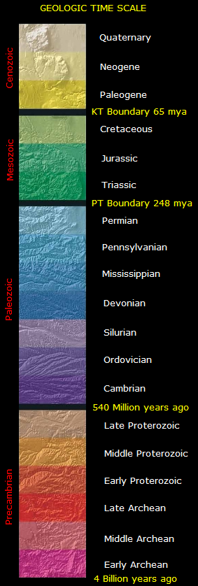
This is the time scale for the North America Tapestry of Time and Terrain map. |
| Date | (UTC) |
| Source | |
| Author |
|

This image is in the public domain in the United States because it only contains materials that originally came from the United States Geological Survey, an agency of the United States Department of the Interior. For more information, see the official USGS copyright policy.
|
Original upload log
This image is a derivative work of the following images:
- Image:North_america_terrain_2003_time_scale.jpg licensed with PD-USGov-USGS
- 2005-09-16T16:01:49Z Saperaud 672x1077 (331996 Bytes) This is the time scale for the [[North America]] Tapestry of Time and Terrain map. Image:North america terrain 2003 map.jpg == Source == [[Image:North america terrain 2003.jpg|thumb|left|[[North America]] Tapestry of Tim
Uploaded with derivativeFX
File history
Click on a date/time to view the file as it appeared at that time.
| Date/Time | Thumbnail | Dimensions | User | Comment | |
|---|---|---|---|---|---|
| current | 16:29, 17 December 2008 | 283 × 838 (176 KB) | Pinkfud | {{Information |Description=This is the time scale for the North America Tapestry of Time and Terrain map. <gallery> Image:North america terrain 2003 map.jpg </gallery> |Source=*Image:North_america_terrain_2003_time_scale.jpg |Date=2008-12-17 16 |
File usage
The following page uses this file:
Global file usage
The following other wikis use this file:
- Usage on es.wikibooks.org
- Usage on fr.wikipedia.org