File:ElectoralCollege1988-Large.png
Size of this preview: 800 × 430 pixels. Other resolutions: 320 × 172 pixels | 640 × 344 pixels | 1,182 × 635 pixels.
Original file (1,182 × 635 pixels, file size: 170 KB, MIME type: image/png)
|
|
This is a file from the Wikimedia Commons |
| U.S. presidential election maps from the National Atlas of the United States |
| See also: SVG maps |
| 1789 · 1792 · 1796 · 1800 · 1804 · 1808 · 1812 · 1816 · 1820 · 1824 · 1828 · 1832 · 1836 · 1840 · 1844 · 1848 · 1852 · 1856 · 1860 · 1864 · 1868 · 1872 · 1876 · 1880 · 1884 · 1888 · 1892 · 1896 · 1900 · 1904 · 1908 · 1912 · 1916 · 1920 · 1924 · 1928 · 1932 · 1936 · 1940 · 1944 · 1948 · 1952 · 1956 · 1960 · 1964 · 1968 · 1972 · 1976 · 1980 · 1984 · 1988 · 1992 · 1996 · 2000 · 2004 |
Summary
| Description |
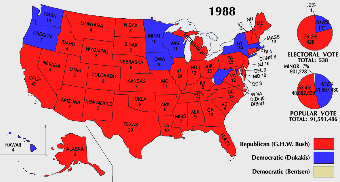
English: 1988 Electoral College Map |
||
| Source | https://nationalmap.gov/small_scale/printable/elections.html | ||
| Author | United States Geological Survey | ||
| Other versions |
|

Licensing
This map was obtained from an edition of the National Atlas of the United States. Like almost all works of the U.S. federal government, works from the National Atlas are in the public domain in the United States.
Online access: NationalAtlas.gov | 1970 print edition: Library of Congress, Perry-Castañeda Library
|
File history
Click on a date/time to view the file as it appeared at that time.
| Date/Time | Thumbnail | Dimensions | User | Comment | |
|---|---|---|---|---|---|
| current | 10:21, 25 July 2007 | | 1,182 × 635 (170 KB) | Cardsplayer4life~commonswiki | Reverted to earlier revision |
| 09:31, 25 July 2007 |  | 1,182 × 635 (110 KB) | Joseph Solis in Australia~commonswiki | {{PD-USGov-Atlas}} Category:1988 {{US presidential election maps}} | |
| 01:47, 9 July 2007 |  | 1,182 × 635 (170 KB) | Cardsplayer4life~commonswiki | {{PD-USGov-Atlas}} {{US presidential election maps}} | |
| 09:34, 6 July 2007 |  | 1,182 × 635 (110 KB) | Joseph Solis in Australia~commonswiki | {{PD-USGov-Atlas}} Category:1988 {{US presidential election maps}} | |
| 02:29, 2 July 2007 |  | 1,182 × 635 (170 KB) | Cardsplayer4life~commonswiki | {{PD-USGov-Atlas}} {{US presidential election maps}} | |
| 10:13, 29 June 2007 |  | 1,182 × 635 (110 KB) | Joseph Solis in Australia~commonswiki | {{PD-USGov-Atlas}} Category:1988 {{US presidential election maps}} | |
| 21:06, 21 June 2007 |  | 1,182 × 635 (170 KB) | Cardsplayer4life~commonswiki | {{PD-USGov-Atlas}} Category:1988 {{US presidential election maps}} | |
| 16:05, 22 January 2006 |  | 1,182 × 635 (110 KB) | Red devil 666 | {{PD-USGov-Atlas}} |
File usage
There are no pages that use this file.
Global file usage
The following other wikis use this file:
- Usage on da.wikipedia.org
- Usage on en.wikipedia.org
- Usage on nl.wikipedia.org
- Usage on no.wikipedia.org
- Usage on sv.wikipedia.org
- Usage on uk.wikipedia.org