File:WestAfrica1350.png
No higher resolution available.
WestAfrica1350.png (413 × 291 pixels, file size: 14 KB, MIME type: image/png)
|
|
This is a file from the Wikimedia Commons |
Summary
| Description |
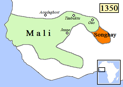
English: Map of West Africa, AD 1350.
(Partially based on Atlas of World History (2007) - Islam and new states in Africa, map.) |
| Date | |
| Source | Own work |
| Author | Gabagool |
| Other versions |
|

Licensing
I, the copyright holder of this work, hereby publish it under the following license:
This file is licensed under the Creative Commons Attribution 3.0 Unported license.
- You are free:
- to share – to copy, distribute and transmit the work
- to remix – to adapt the work
- Under the following conditions:
- attribution – You must give appropriate credit, provide a link to the license, and indicate if changes were made. You may do so in any reasonable manner, but not in any way that suggests the licensor endorses you or your use.
File history
Click on a date/time to view the file as it appeared at that time.
| Date/Time | Thumbnail | Dimensions | User | Comment | |
|---|---|---|---|---|---|
| current | 00:14, 16 June 2009 | | 413 × 291 (14 KB) | Gabagool | rm lines |
| 00:24, 20 April 2009 |  | 413 × 291 (16 KB) | Gabagool | {{Information |Description={{en|1=Map of West Africa, AD 1350. (Partially based on ''Atlas of World History'' (2007) - Islam and new states in Africa, map.)}} |Source=Own work by uploader |Author=Gabagool / Jarle Grøhn |Date=2009-04-20 |
File usage
The following page uses this file:
Global file usage
The following other wikis use this file:
- Usage on als.wikipedia.org
- Usage on ca.wikipedia.org
- Usage on en.wikipedia.org
- Usage on fr.wikipedia.org
- Usage on hu.wikipedia.org
- Usage on it.wikipedia.org
- Usage on ja.wikipedia.org
- Usage on ka.wikipedia.org
- Usage on nn.wikipedia.org
- Usage on ru.wikipedia.org