File:The Blue Marble 4463x4163.jpg

Original file (4,463 × 4,163 pixels, file size: 5.9 MB, MIME type: image/jpeg)
|
|
This is a file from the Wikimedia Commons |
Summary
| Description |
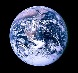
Deutsch: „Blue Marble“, die während des Fluges von Apollo 17 zum Mond am 7. Dezember 1972 entstandene Fotoaufnahme von der Erde (in der zur besseren Wiedererkennbarkeit um 180 Grad gedrehten Version).
English: "The Blue Marble" is a famous photograph of the Earth taken on December 7, 1972 by the crew of the Apollo 17 spacecraft en route to the Moon at a distance of about 29,400 kilometres (18,300 mi). It shows Africa, Antarctica, and the Arabian Peninsula.
Français : «La bille bleue» : Photo de l'Afrique, de l'Antarctique et de la péninsule Arabique prise en route pour la lune par Harrison Schmitt ou Ron Evans lors de la mission Apollo 17 le 7 décembre 1972. Ce vol a été le dernier à quitter l'orbite terrestre, et le seul au cours duquel un géologue, Harrison Schmitt, s'est rendu sur la lune.
|
|||||
| Date | ||||||
| Source |
|
|||||
| Author | NASA. Photo taken by either Harrison Schmitt or Ron Evans (of the Apollo 17 crew). | |||||
| Permission (Reusing this file) |
|
|||||
| Other versions |
[] Other versions:
Derivative works:
|

.jpg)
.jpg)
.jpg)


.jpg)


Other information from NASA about this image:
| “ | Earth - Apollo 17
Full Earth showing Africa and Antarctica
Location & Time Information |
” |
File history
Click on a date/time to view the file as it appeared at that time.
| Date/Time | Thumbnail | Dimensions | User | Comment | |
|---|---|---|---|---|---|
| current | 16:07, 16 November 2010 | | 4,463 × 4,163 (5.9 MB) | Jeff G. | == {{int:filedesc}} == {{Information |Description={{de|„Blue Marble“, die während des Fluges von Apollo 17 zum Mond am 7. Dezember 1972 entstandene Fotoaufnahme von der Erde (in der zur besseren Wiedererkennbarke |
File usage
The following 5 pages use this file:
Global file usage
The following other wikis use this file:
- Usage on arz.wikipedia.org
- Usage on bcl.wikipedia.org
- Usage on beta.wikiversity.org
- Usage on en.wikipedia.org
- Usage on en.wikiquote.org
- Usage on en.wikiversity.org
- Usage on fr.wikipedia.org
- Usage on it.wikipedia.org
- Usage on pl.wiktionary.org
- Usage on th.wikipedia.org
- Usage on tpi.wikipedia.org