File:Huperzia selago nymap.svg

Size of this PNG preview of this SVG file: 600 × 460 pixels. Other resolutions: 313 × 240 pixels | 626 × 480 pixels | 1,002 × 768 pixels | 1,280 × 981 pixels | 2,560 × 1,963 pixels.
Original file (SVG file, nominally 600 × 460 pixels, file size: 749 KB)
|
|
This is a file from the Wikimedia Commons |
Summary
| Description |
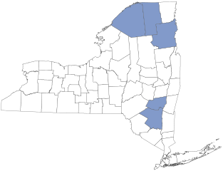
English: New York State county-level flora distribution map. Counties indicated are based primarily on data from Weldy, Troy, David Werier, and Andrew Nelson. 2013 New York Flora Atlas. New York Flora Association, Albany, New York. |
| Date | |
| Source | Own work |
| Author | Nonenmac |
Licensing
I, the copyright holder of this work, hereby publish it under the following license:
This file is licensed under the Creative Commons Attribution-Share Alike 3.0 Unported license.
- You are free:
- to share – to copy, distribute and transmit the work
- to remix – to adapt the work
- Under the following conditions:
- attribution – You must give appropriate credit, provide a link to the license, and indicate if changes were made. You may do so in any reasonable manner, but not in any way that suggests the licensor endorses you or your use.
- share alike – If you remix, transform, or build upon the material, you must distribute your contributions under the same or compatible license as the original.
File history
Click on a date/time to view the file as it appeared at that time.
| Date/Time | Thumbnail | Dimensions | User | Comment | |
|---|---|---|---|---|---|
| current | 01:13, 11 July 2018 | | 600 × 460 (749 KB) | Nonenmac | fixed steuben county error (missing white space) |
| 00:05, 11 July 2018 |  | 600 × 460 (727 KB) | Nonenmac | the spurious line extends into Oswego County, so checking that now | |
| 00:01, 11 July 2018 |  | 600 × 460 (727 KB) | Nonenmac | trying again with adjacent Seneca County | |
| 23:58, 10 July 2018 |  | 600 × 460 (727 KB) | Nonenmac | another test shot | |
| 23:55, 10 July 2018 |  | 600 × 460 (727 KB) | Nonenmac | minor change to test why Ontario County outline is not rendering correctly in pngs. | |
| 22:04, 10 July 2018 |  | 600 × 460 (727 KB) | Nonenmac | changed to transparent background & more detail | |
| 13:49, 20 September 2013 |  | 668 × 501 (317 KB) | Nonenmac | User created page with UploadWizard |
File usage
The following page uses this file: