File:Greystoke Castle.jpg
No higher resolution available.
Greystoke_Castle.jpg (640 × 480 pixels, file size: 118 KB, MIME type: image/jpeg)
|
|
This is a file from the Wikimedia Commons |
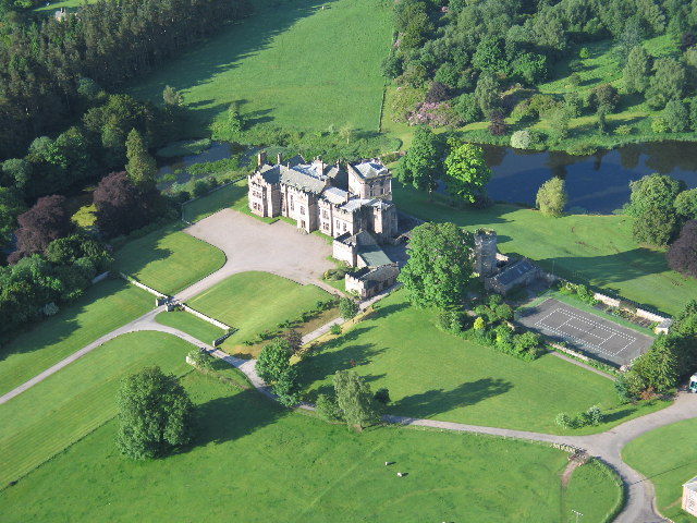
| Description | Greystoke Castle is in the village of Greystoke 8 km west of Penrith in the county of Cumbria in northern England. |
| Date | 2005-09-08T19:54:30+00:00 |
| Source | From geograph.co.uk |
| Author | Simon Ledingham |
| Permission (Reusing this file) |
Creative Commons Attribution Share-alike license 2.0 |
| Camera location | | View this and other nearby images on: OpenStreetMap |
|---|

|
This image was taken from the Geograph project collection. See this photograph's page on the Geograph website for the photographer's contact details. The copyright on this image is owned by Simon Ledingham and is licensed for reuse under the Creative Commons Attribution-ShareAlike 2.0 license.
|
This file is licensed under the Creative Commons Attribution-Share Alike 2.0 Generic license.
Attribution: Simon Ledingham
- You are free:
- to share – to copy, distribute and transmit the work
- to remix – to adapt the work
- Under the following conditions:
- attribution – You must give appropriate credit, provide a link to the license, and indicate if changes were made. You may do so in any reasonable manner, but not in any way that suggests the licensor endorses you or your use.
- share alike – If you remix, transform, or build upon the material, you must distribute your contributions under the same or compatible license as the original.
File history
Click on a date/time to view the file as it appeared at that time.
| Date/Time | Thumbnail | Dimensions | User | Comment | |
|---|---|---|---|---|---|
| current | 16:52, 3 June 2008 | | 640 × 480 (118 KB) | Arthena | {{Information |Description=Greystoke Castle is in the village of Greystoke 8 km west of Penrith in the county of Cumbria in northern England. |Source=From [http://www.geograph.org.uk/photo/50875 geograph.co.uk] |Date=2005-09-08T19:54:30+00:00 |Author=[ht |
File usage
The following 2 pages use this file:
Global file usage
The following other wikis use this file:
- Usage on ceb.wikipedia.org
- Usage on da.wikipedia.org
- Usage on de.wikipedia.org
- Usage on en.wikipedia.org
- List of castles in England
- History of Cumbria
- Quadrangular castle
- Greystoke Castle
- User:Nev1/Sandbox
- Portal:Cumbria
- List of country houses in the United Kingdom
- Talk:List of castles in England/sandbox/option1
- List of work on castles and country houses by Anthony Salvin
- Grade II* listed buildings in Eden District
- User:Nev1/sandbox
- Listed buildings in Greystoke, Cumbria
- Usage on es.wikipedia.org
- Usage on fr.wikipedia.org
- Usage on it.wikipedia.org
- Usage on pnb.wikipedia.org
- Usage on pt.wikipedia.org
- Usage on ru.wikipedia.org
- Usage on sv.wikipedia.org
- Usage on www.wikidata.org